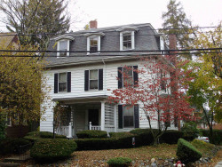
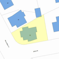
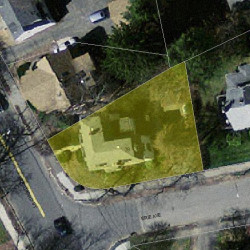
39 Woodward St Newton, MA 02461-1536
Visit 39 Woodward St in Newton, MA, 02461-1536
This profile includes property assessor report information, real estate records and a complete residency history.
We have include the current owner’s name and phone number to help you find the right person and learn more.
Sold Jul 2022
$1,276,000
Market Activities
Jul 2022 - Jun 2023
PROPERTY OVERVIEW
Type: Single Family
5 beds2.5 baths3,939 sqft
5 beds2.5 baths3,939 sqft
Facts
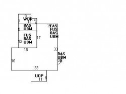
Built in 1890Trim: None Property use: Single FamilyFoundation type: Brick/Fldstone Lot size: 4,581 sqftRoof type: Mansard Effective area: 3,939 sqftRoof material: Asphalt Shingl Building type: ResidentialHeat type: Steam Rooms: 9Fuel type: Gas Bedrooms: 5Frontage: 30 feet Bathrooms: 2Finished attic area: 783 sqft Stories: 3Basement area: 1,025 sqft Exterior condition: AveragePorch area: 88 sqft Exterior walls: Vinyl SidingDeck area: 79 sqft
Features
Kitchen quality: Above Average
Recent residents
| Resident Name | Phone | More Info |
|---|---|---|
| Mary L Tavares | Status: Last owner (from Sep 01, 1964 to now) |
|
| Louis G Tavares | Status: Last owner (from Sep 01, 1964 to now) |
|
| Riva Darwin | Status: Previous owner (from Jan 14, 1952 to Sep 01, 1964) |
|
| Hirschel H Darwin | Status: Previous owner (from Jan 14, 1952 to Sep 01, 1964) |
|
| Gerhardt W Lang | Status: Previous owner (from Apr 25, 1951 to Jan 14, 1952) |
|
| Catherine F Lang | Status: Previous owner (from Apr 25, 1951 to Jan 14, 1952) |
|
| Adeline D Breil | Status: Previous owner (to Apr 25, 1951) |
|
| Amy C Feldstein, age 64 | (617) 964-7048 | Status: Homeowner |
| Barbara Feldstein, age 87 | (617) 964-7048 | |
| Gabriel Feldstein | (617) 964-7048 | |
| Amy C Mazur, age 64 | (617) 964-7048 | |
| Bernard B Feldstein, age 88 | (617) 969-5659 | |
| Jesse Feldstein | (617) 969-5659 | |
| Michael S Feldstein, age 63 | (617) 969-5659 | |
| Mike S Feldstein, age 63 | (617) 969-5659 | Status: Homeowner Education: High school graduate or higher |
Neighbors
Real estate transaction history
| Date | Event | Price | Source | Agents |
|---|---|---|---|---|
| 06/28/1991 | Sold | $205,000 | Public records |
Assessment history
| Year | Tax | Assessment | Market |
|---|---|---|---|
| 2016 | $627,600.00 | ||
| 2015 | $530,900.00 | ||
| 2014 | $509,800.00 | ||
| 2013 | $509,800.00 | ||
| 2012 | $509,800.00 | ||
| 2011 | $505,100.00 | ||
| 2010 | $515,400.00 | ||
| 2009 | $525,900.00 | ||
| 2008 | $525,900.00 | ||
| 2007 | $560,700.00 | ||
| 2006 | $544,400.00 | ||
| 2005 | $518,500.00 | ||
| 2004 | $482,200.00 | ||
| 2003 | $430,500.00 | ||
| 2002 | $430,500.00 | ||
| 2001 | $353,700.00 | ||
| 2000 | $323,000.00 | ||
| 1999 | $293,900.00 | ||
| 1998 | $235,200.00 | ||
| 1997 | $215,800.00 | ||
| 1996 | $205,500.00 | ||
| 1995 | $212,400.00 | ||
| 1994 | $206,200.00 | ||
| 1993 | $206,200.00 | ||
| 1992 | $275,200.00 |
Fire Incidents History
24 Sep 2008
Building fires
Property Use: 1 or 2 family dwelling
Actions Taken: Extinguish
Area of Origin: Common room, den, family room, living room, lounge
First Ignition: Electrical wire, cable insulation
Heat Source: Heat source: other
Factors Contributing to Ignition: Equipment not being operated properly
Equipment Involved: Heating, Ventilating & Air Conditioning
Equipment Power: Electrical line voltage (>= 50 volts)
Equipment Portability: Stationary
Property Loss: $5,000