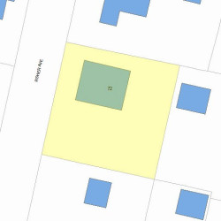
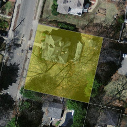
72 Fisher Ave Newton, MA 02461-1107
Visit 72 Fisher Ave in Newton, MA, 02461-1107
This profile includes property assessor report information, real estate records and a complete residency history.
We have include the current owner’s name and phone number to help you find the right person and learn more.
Sold Feb 2024
$2,160,000

Market Activities
Feb 2024 - Feb 2024
Feb 2024 - Feb 2024
PROPERTY OVERVIEW
Type: Single Family
6 beds2.5 baths4,909 sqft
6 beds2.5 baths4,909 sqft
Facts
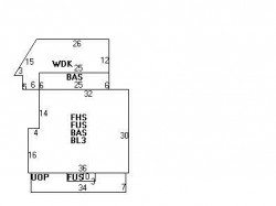
Built in 1890Trim: None Property use: Single FamilyFoundation type: Brick/Fldstone Lot size: 10,000 sqftRoof type: Hip Effective area: 3,885 sqftRoof material: Asphalt Shingl Gross building area: 4,909 sqftHeat type: Hot Wtr Radiat Building type: ResidentialFuel type: Gas Rooms: 10Frontage: 100 feet Bedrooms: 6Basement area: 1,024 sqft Bathrooms: 2Finished basement area: 512 sqft Stories: 2.5Shed area: 80 sqft Exterior condition: AveragePorch area: 238 sqft Exterior walls: ClapboardDeck area: 395 sqft
Features
Kitchen quality: Above AverageInterior condition: Good
Recent residents
| Resident Name | Phone | More Info |
|---|---|---|
| Nancy J Nelson, age 64 | (617) 928-1209 | Status: Last owner (from Jul 01, 1998 to now) |
| Jay P Nelson, age 66 | (617) 928-1070 | Status: Last owner (from Jul 01, 1998 to now) |
| William D Mclaurin, age 85 | (617) 332-4635 | Status: Previous owner (to Jul 01, 1998) |
| Beverly Mclaurin, age 84 | (617) 332-4635 | |
| Joyce Mclaurin | (617) 332-4635 | |
| Kim Mclaurin, age 60 | (617) 332-4635 | |
| B Joyce Mclaurin | Status: Previous owner (to Jul 01, 1998) |
|
| Beatrice Tzudiker | Status: Previous owner (from Feb 14, 1958) |
|
| Harvey S Tzudiker | Status: Previous owner (from Feb 14, 1958) |
|
| Charles L Fenton Jr | Status: Previous owner (to Feb 14, 1958) |
|
| Priscilla Fenton | Status: Previous owner (to Feb 14, 1958) |
Neighbors
Real estate transaction history
| Date | Event | Price | Source | Agents |
|---|---|---|---|---|
| 07/01/1998 | Sold | $505,000 | Public records |
Assessment history
| Year | Tax | Assessment | Market |
|---|---|---|---|
| 2016 | $1,109,100.00 | ||
| 2015 | $1,036,500.00 | ||
| 2014 | $987,000.00 | ||
| 2013 | $987,000.00 | ||
| 2012 | $939,400.00 | ||
| 2011 | $924,500.00 | ||
| 2010 | $943,400.00 | ||
| 2009 | $962,700.00 | ||
| 2008 | $962,700.00 | ||
| 2007 | $984,300.00 | ||
| 2006 | $955,600.00 | ||
| 2005 | $910,100.00 | ||
| 2004 | $767,100.00 | ||
| 2003 | $684,900.00 | ||
| 2002 | $684,400.00 | ||
| 2001 | $589,900.00 | ||
| 2000 | $538,700.00 | ||
| 1999 | $490,200.00 | ||
| 1998 | $427,500.00 | ||
| 1997 | $392,200.00 | ||
| 1996 | $373,500.00 | ||
| 1995 | $358,900.00 | ||
| 1994 | $326,300.00 | ||
| 1993 | $326,300.00 | ||
| 1992 | $328,800.00 |
Incidents registered in Federal Emergency Management Agency
29 Oct 2011
Power line down
Property Use: 1 or 2 family dwelling
Actions Taken: Incident command
Actions Taken: Incident command