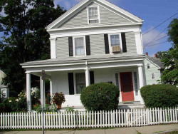
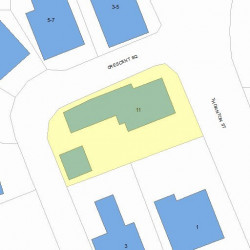
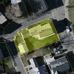
11 Thornton St Newton, MA 02458-1520
Visit 11 Thornton St in Newton, MA, 02458-1520
This profile includes property assessor report information, real estate records and a complete residency history.
We have include the current owner’s name and phone number to help you find the right person and learn more.
Sold Feb 2023
$926,500
Market Activities
Jan 2023 - Mar 2023
Feb 2023 - Feb 2023
Jan 2023 - Mar 2023
PROPERTY OVERVIEW
Type: Two Family
3 beds2 baths4,212 sqft
3 beds2 baths4,212 sqft
Facts
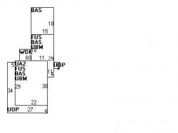
Built in 1890Foundation type: Brick/Fldstone Property use: Two FamilyRoof type: Gable Lot size: 5,666 sqftRoof material: Slate Effective area: 3,882 sqftHeat type: Steam Gross building area: 4,212 sqftFuel type: Oil Building type: ResidentialFrontage: 55 feet Rooms: 9Unfinished attic area: 330 sqft Bedrooms: 3Basement area: 974 sqft Stories: 2Porch area: 296 sqft Exterior condition: FairDeck area: 64 sqft Exterior walls: ClapboardDetached garage area: 342 sqft Trim: None
Features
Kitchen quality: Below AverageInterior condition: Good Bath quality: Average
Recent residents
| Resident Name | Phone | More Info |
|---|---|---|
| Albert Altieri | ||
| David J Altieri, age 71 | (978) 264-9418 | |
| Joyce L Ananian | ||
| Laurie A Doherty #A | ||
| Katherine Dutmer | (617) 467-5247 | |
| Susan J Lemieux #A | (617) 244-7478 | |
| Susan J Marble, age 58 #A | (617) 244-7478 | |
| Daniel H Malia, age 94 | Status: Renter Occupation: Sales Occupations |
|
| Danl Malia, age 94 | Status: Renter |
|
| Gladys A Malia, age 96 | Status: Renter Occupation: Sales Occupations Email: |
Neighbors
Assessment history
| Year | Tax | Assessment | Market |
|---|---|---|---|
| 2016 | $531,300.00 | ||
| 2015 | $496,500.00 | ||
| 2014 | $471,200.00 | ||
| 2013 | $471,200.00 | ||
| 2012 | $471,200.00 | ||
| 2011 | $477,200.00 | ||
| 2010 | $486,900.00 | ||
| 2009 | $512,500.00 | ||
| 2008 | $512,500.00 | ||
| 2007 | $545,600.00 | ||
| 2006 | $529,700.00 | ||
| 2005 | $514,300.00 | ||
| 2004 | $364,500.00 | ||
| 2003 | $319,700.00 | ||
| 2002 | $319,700.00 | ||
| 2001 | $268,700.00 | ||
| 2000 | $245,400.00 | ||
| 1999 | $223,300.00 | ||
| 1998 | $203,100.00 | ||
| 1997 | $203,100.00 | ||
| 1996 | $193,400.00 | ||
| 1995 | $192,100.00 | ||
| 1994 | $202,200.00 | ||
| 1993 | $202,200.00 | ||
| 1992 | $210,800.00 |
Incidents registered in Federal Emergency Management Agency
19 Feb 2014
Power line down
Property Use: 1 or 2 family dwelling
Actions Taken: Investigate
Actions Taken: Investigate