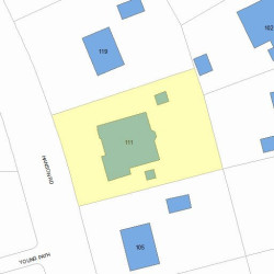
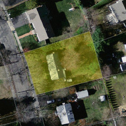
111 Hanson Rd Newton, MA 02459-3627
Visit 111 Hanson Rd in Newton, MA, 02459-3627
This profile includes property assessor report information, real estate records and a complete residency history.
We have include the current owner’s name and phone number to help you find the right person and learn more.
Building Permits
Apr 9, 2013
Description: Build new single family home
- Contractor: Pine Cone Construction Inc.
- Valuation: $40,000,000
- Fee: $7,440.00 paid to City of Newton, Massachusetts
- Parcel #: 84027 0016
- Permit #: 13030543
Mar 22, 2013
Description: Demo house and sheds
- Contractor: Pine Cone Construction Inc.
- Fee: $15.50 paid to City of Newton, Massachusetts
- Parcel #: 84027 0016
- Permit #: 13030591
PROPERTY OVERVIEW
Type: Single Family
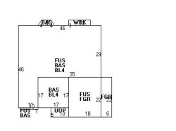
5 beds5.5 baths6,192 sqft
5 beds5.5 baths6,192 sqft
Facts
Built in 2013Foundation type: Concrete Property use: Single FamilyRoof type: Hip Lot size: 12,720 sqftRoof material: Asphalt Shingl Effective area: 5,740 sqftHeat type: Forced Air-Duc Gross building area: 6,192 sqftFuel type: Gas Building type: ResidentialAir conditioning: Central Rooms: 10Fireplaces: 1 Bedrooms: 5Frontage: 110 feet Bathrooms: 6Basement area: 1,810 sqft Stories: 2Finished basement area: 1,358 sqft Exterior condition: ExcellentPorch area: 50 sqft Exterior walls: Stucco on WoodDeck area: 36 sqft Trim: NoneAttached garage area: 528 sqft
Features
Kitchen quality: Good
Recent residents
| Resident Name | Phone | More Info |
|---|---|---|
| XU DAIHUAN | Status: Last owner (from Aug 19, 2013 to now) |
|
| Zhixin Wu | Status: Last owner (from Aug 19, 2013 to now) |
|
| 111 HANSON ROAD LLC | Status: Previous owner (from Feb 15, 2013 to Aug 19, 2013) |
|
| LAMOS MADLYN B EST | Status: Previous owner (to Feb 15, 2013) |
|
| Gail G Mulcahy | Status: Previous owner (to Feb 15, 2013) |
|
| William F Dietrich | (617) 928-0000 | |
| John R Lamos, age 111 | (617) 332-2492 | |
| Madlyn B Lamos, age 105 | (617) 332-2492 |
Neighbors
Assessment history
| Year | Tax | Assessment | Market |
|---|---|---|---|
| 2016 | $1,585,700.00 | ||
| 2015 | $1,482,000.00 | ||
| 2014 | $392,500.00 | ||
| 2013 | $350,700.00 | ||
| 2012 | $350,700.00 | ||
| 2011 | $351,100.00 | ||
| 2010 | $358,300.00 | ||
| 2009 | $365,600.00 | ||
| 2008 | $365,600.00 | ||
| 2007 | $414,100.00 | ||
| 2006 | $402,000.00 | ||
| 2005 | $382,900.00 | ||
| 2004 | $317,400.00 | ||
| 2003 | $283,400.00 | ||
| 2002 | $283,400.00 | ||
| 2001 | $251,100.00 | ||
| 2000 | $229,300.00 | ||
| 1999 | $208,600.00 | ||
| 1998 | $185,000.00 | ||
| 1997 | $169,700.00 | ||
| 1996 | $169,700.00 | ||
| 1995 | $156,100.00 | ||
| 1994 | $153,000.00 | ||
| 1993 | $153,000.00 | ||
| 1992 | $166,100.00 |
Incidents registered in Federal Emergency Management Agency
07 Oct 2003
Public service assistance, other
Property Use: 1 or 2 family dwelling
Actions Taken: Investigate
Actions Taken: Investigate