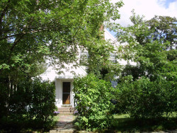
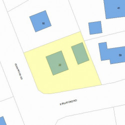
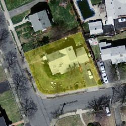
22 Fernwood Rd Newton, MA 02465-1807
Visit 22 Fernwood Rd in Newton, MA, 02465-1807
This profile includes property assessor report information, real estate records and a complete residency history.
We have include the current owner’s name and phone number to help you find the right person and learn more.
PROPERTY OVERVIEW
Type: Single Family
4 beds3 baths3,540 sqft
4 beds3 baths3,540 sqft
Facts
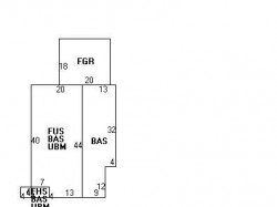
Built in 1938Trim: None Property use: Single FamilyFoundation type: Concrete Lot size: 8,587 sqftRoof type: Gable Effective area: 3,526 sqftRoof material: Asphalt Shingl Gross building area: 3,540 sqftHeat type: Hot Wtr Radiat Building type: ResidentialFuel type: Gas Rooms: 9Fireplaces: 1 Bedrooms: 4Frontage: 175 feet Stories: 2Basement area: 880 sqft Exterior condition: AverageEnclosed porch area: 16 sqft Exterior walls: Wood ShingleAttached garage area: 360 sqft
Features
Kitchen quality: Above AverageInterior condition: Good
Recent residents
| Resident Name | Phone | More Info |
|---|---|---|
| Kevin L Hartshorn, age 76 | (617) 969-7016 | Status: Homeowner Occupation: Medical Professional Education: Graduate or professional degree |
| Ruthe Kandel, age 73 | (617) 969-7016 | |
| Bobbi Jo Greene, age 57 | (508) 734-5237 | |
| Max W Hartshorn | (617) 851-4611 | |
| Ruth Hartshorn, age 103 | Occupation: Retired Education: High school graduate or higher |
|
| Ruth Kandel, age 73 | Status: Homeowner Occupation: Medical Professional Education: Graduate or professional degree |
Business records related to this address
| Organization | Phone | More Info |
|---|---|---|
| Kevan Hartshorn | (617) 969-7016 | SIC: 6022 - State Commercial Banks |
| Kevan L Hartshorn, age 76 | (617) 784-9959 | Status: Homeowner Occupation: Construction and Extraction Occupations Email: Organization: Kevan Hartshorn Title: COO Specialties: Other Depository Credit Intermediation; State Commercial Banks |
Neighbors
Assessment history
| Year | Tax | Assessment | Market |
|---|---|---|---|
| 2016 | $743,200.00 | ||
| 2015 | $694,600.00 | ||
| 2014 | $659,600.00 | ||
| 2013 | $659,600.00 | ||
| 2012 | $659,600.00 | ||
| 2011 | $667,600.00 | ||
| 2010 | $681,200.00 | ||
| 2009 | $695,100.00 | ||
| 2008 | $695,100.00 | ||
| 2007 | $711,500.00 | ||
| 2006 | $690,800.00 | ||
| 2005 | $657,900.00 | ||
| 2004 | $603,300.00 | ||
| 2003 | $538,700.00 | ||
| 2002 | $538,700.00 | ||
| 2001 | $430,800.00 | ||
| 2000 | $393,400.00 | ||
| 1999 | $358,000.00 | ||
| 1998 | $302,000.00 | ||
| 1997 | $286,300.00 | ||
| 1996 | $272,700.00 | ||
| 1995 | $258,000.00 | ||
| 1994 | $245,700.00 | ||
| 1993 | $196,500.00 | ||
| 1992 | $202,600.00 |
Incidents registered in Federal Emergency Management Agency
15 Feb 2003
Unintentional transmission of alarm, other
Property Use: 1 or 2 family dwelling
Actions Taken: Investigate
Actions Taken: Investigate