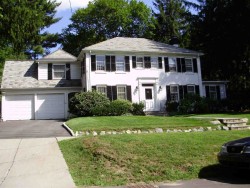
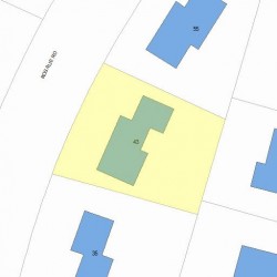
43 Rosalie Rd Newton, MA 02459-3131
Visit 43 Rosalie Rd in Newton, MA, 02459-3131
This profile includes property assessor report information, real estate records and a complete residency history.
We have include the current owner’s name and phone number to help you find the right person and learn more.
PROPERTY OVERVIEW
Type: Single Family
5 beds2.5 baths4,856 sqft
5 beds2.5 baths4,856 sqft
Facts
Built in 1928Foundation type: Concrete Property use: Single FamilyRoof type: Hip Lot size: 11,320 sqftRoof material: Slate Effective area: 4,664 sqftHeat type: Forced Air-Duc Gross building area: 4,856 sqftFuel type: Gas Building type: ResidentialAir conditioning: Central Rooms: 10Fireplaces: 3 Bedrooms: 5Frontage: 100 feet Stories: 2Basement area: 1,204 sqft Exterior condition: AverageFinished basement area: 250 sqft Exterior walls: Wood ShingleAttached garage area: 216 sqft Trim: Two Wall


Features
Kitchen quality: Above AverageInterior condition: Good
Recent residents
| Resident Name | Phone | More Info |
|---|---|---|
| Ellen K Rosenblatt, age 67 | (617) 630-0257 | Status: Last owner (from Oct 09, 1996 to now) Occupation: Financial Professional Education: Graduate or professional degree Email: |
| David P Rosenblatt, age 67 | (617) 630-0257 | Status: Previous owner (from Dec 14, 1994 to Oct 09, 1996) Occupation: Legal Professional Education: Graduate or professional degree Email: |
| Elizabeth K Rosenblatt | Status: Previous owner (from Dec 14, 1994 to Apr 29, 1996) |
|
| Alberta K Shapiro | Status: Previous owner (to Dec 14, 1994) |
|
| Edward A Shapiro | Status: Previous owner (to Dec 14, 1994) |
|
| E M Golding | ||
| Samuel H Rosenblatt, age 27 | (617) 969-8136 | Status: Renter |
Neighbors
Real estate transaction history
| Date | Event | Price | Source | Agents |
|---|---|---|---|---|
| 12/14/1994 | Sold | $500,000 | Public records |
Assessment history
| Year | Tax | Assessment | Market |
|---|---|---|---|
| 2016 | $1,128,000.00 | ||
| 2015 | $1,054,200.00 | ||
| 2014 | $1,012,100.00 | ||
| 2013 | $1,012,100.00 | ||
| 2012 | $1,012,100.00 | ||
| 2011 | $999,000.00 | ||
| 2010 | $1,019,400.00 | ||
| 2009 | $1,040,200.00 | ||
| 2008 | $1,040,200.00 | ||
| 2007 | $1,075,100.00 | ||
| 2006 | $1,043,800.00 | ||
| 2005 | $994,100.00 | ||
| 2004 | $935,800.00 | ||
| 2003 | $835,500.00 | ||
| 2002 | $835,500.00 | ||
| 2001 | $636,400.00 | ||
| 2000 | $581,200.00 | ||
| 1999 | $528,800.00 | ||
| 1998 | $490,500.00 | ||
| 1997 | $490,500.00 | ||
| 1996 | $467,100.00 | ||
| 1995 | $405,400.00 | ||
| 1994 | $386,100.00 | ||
| 1993 | $386,100.00 | ||
| 1992 | $407,800.00 |
Incidents registered in Federal Emergency Management Agency
11 Mar 2012
Cooking fire, confined to container
Property Use: 1 or 2 family dwelling
Actions Taken: Incident command
Actions Taken: Incident command
11 Aug 2007
Power line down
Property Use: Residential street, road or residential driveway
Actions Taken: Standby
Actions Taken: Standby