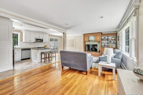
70 Far Horizon Dr Upper Stepney, CT 06468-1726
Visit 70 Far Horizon Dr in Upper Stepney, CT, 06468-1726
This profile includes property assessor report information, real estate records and a complete residency history.
We have include the current owner’s name and phone number to help you find the right person and learn more.
For Sale
$499,900
Market Activities
Aug 2023 - present
PROPERTY OVERVIEW
Type: Single Family Residential
4 beds2 bathsLot: 1.04 acres
4 beds2 bathsLot: 1.04 acres
Facts
Built in 1964Exterior material: Wood Lot size: 1.04 acresStyle: Colonial Rooms: 8Exterior walls: Wood Siding Bedrooms: 4Basement: Full Basement Bathrooms: 2Heat type: Hot Water Stories: 2 story with basement
Features
FireplaceA/C
Listing info
Last sold: Mar 1989 for $240,000
Recent residents
| Resident Name | Phone | More Info |
|---|---|---|
| E Courbron, age 82 | (203) 452-9989 | |
| Elizabeth A Courbron, age 61 | (203) 452-9989 | |
| Michael B Courbron, age 64 | (203) 452-9989 | Status: Homeowner Occupation: Service Occupations Education: Associate degree or higher |
| Tyler Martin | ||
| William J Mcnamara | (203) 268-5220 |
Business records related to this address
| Organization | Phone | More Info |
|---|---|---|
| COUB DRYWALL ASSOCIATES, INC | Business type: Stock |
|
| CUSTOM DRYWALL CONSTRUCTION LLC | Business type: Domestic Limited Liability Company |
|
| Richard Courborn | Industry: Business Services at Non-Commercial Site |
Historical businesses records
| Organization | Phone | More Info |
|---|---|---|
| COUB DRYWALL, INC | Business type: Stock |
Neighbors
37 Far Horizon Dr
L Monet
L Monet
Real estate transaction history
| Date | Event | Price | Source | Agents |
|---|---|---|---|---|
| 03/01/1989 | Sold | $240,000 | Public records |
Assessment history
| Year | Tax | Assessment | Market |
|---|---|---|---|
| 2014 | $8,019 | $258,580 | N/A |
Fire Incidents History
01 Nov 2000
Outside rubbish fire, other
Property Use: Outside or special property, other
Actions Taken: Extinguish
Area of Origin: Wildland, woods
First Ignition: Rubbish, trash, or waste
Heat Source: Match
Factors Contributing to Ignition: Abandoned or discarded materials or products
Property Loss: $5
Actions Taken: Extinguish
Area of Origin: Wildland, woods
First Ignition: Rubbish, trash, or waste
Heat Source: Match
Factors Contributing to Ignition: Abandoned or discarded materials or products
Property Loss: $5
15 Jun 1999
Cultivated grain or crop fire
Property Use: 1 or 2 family dwelling
Actions Taken: Extinguish
Area of Origin: Open area - outside; included are farmland, field
First Ignition: Rubbish, trash, or waste
Heat Source: Match
Factors Contributing to Ignition: Abandoned or discarded materials or products
Property Loss: $5
Actions Taken: Extinguish
Area of Origin: Open area - outside; included are farmland, field
First Ignition: Rubbish, trash, or waste
Heat Source: Match
Factors Contributing to Ignition: Abandoned or discarded materials or products
Property Loss: $5
Incidents registered in Federal Emergency Management Agency
13 Oct 2007
Authorized controlled burning
Property Use: 1 or 2 family dwelling
Actions Taken: Investigate
Actions Taken: Investigate
20 May 2007
Unauthorized burning
Property Use: Open land or field
Actions Taken: Extinguish
Actions Taken: Extinguish
20 May 2007
Authorized controlled burning
Property Use: 1 or 2 family dwelling
Actions Taken: Investigate
Actions Taken: Investigate
